When you’re exploring the world of real estate, you may come across the term “township.” Understanding what a township is can help you get a better grasp of the property’s location and organization. Don’t worry, it’s not as complicated as it may initially seem.
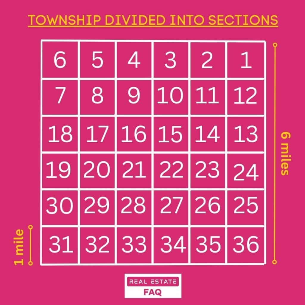
A township is a division of land that measures 6 miles by 6 miles, or 36 square miles, and is established by the intersection of tiers and range lines. Each township consists of 36 sections, with each section measuring one square mile (640 acres). Sections are numbered starting from the northeast corner, with section 1 and continuing in a zigzag pattern until reaching section 36 in the southeast corner.
This system of organization makes it easier to locate and describe vast areas of land, particularly in the United States where the Public Land Survey System (PLSS) was implemented.
Township in Real Estate
In real estate terms, a “township” typically refers to a division of land used for residential, commercial, and industrial purposes. Townships are governed by a local government and have their own set of rules and regulations. They can vary in size and are found in rural, suburban, and urban areas.
As a real estate agent or someone studying for the real estate exam, it’s essential to understand the different survey systems in the United States that contribute to the formation of townships. In this section, we will explore the Rectangular Survey System, Government Survey System, and Public Land Survey System.
Rectangular Survey System
The Rectangular Survey System, also known as the Public Land Survey System (PLSS), is a method of subdividing and describing land in the United States. The system is based on a series of grids that are created by intersecting lines running north-south (meridians) and east-west (baselines). This grid system creates townships, which are typically six miles by six miles square, or 23,040 acres.
Government Survey System
The Government Survey System helps to provide a legal description of a specific parcel of land. A township is identified by specifying how many tiers it is north or south of the baseline, and how many range lines it is east or west of the principal meridian.
For example, a legal description might describe the township as “Tier 4 North, Range 5 West.” As a real estate agent, you may need to be familiar with the Government Survey System to accurately locate and describe properties.
Public Land Survey System
As mentioned earlier, the Public Land Survey System (PLSS) is another name for the Rectangular Survey System. It was established by the General Land Office (now the Bureau of Land Management) to simplify the process of land identification, description, and division for sale or other purposes.
Understanding the different survey systems, is crucial for your real estate exam and your career as a real estate agent. By familiarizing yourself with these systems, you’ll be better equipped to locate and describe properties accurately.
Understanding Townships
In this section, you’ll learn some basic terminology that will help you understand what townships are, including square miles, township lines, and range lines.
Square Miles
In the United States, a survey township is typically six by six miles square, totaling 36 square miles or 23,040 acres. This size allows for the efficient organization and management of land and property within the township.
Township Lines
To understand townships even better, it’s good to familiarize yourself with township lines. These lines run east-west and are parallel to a designated base line. Township lines serve as handy reference points for locating properties within the township. So, when you’re navigating through a township, knowing these lines can make your life much easier.
Range Lines
In addition to township lines, there are range lines that intersect them. Range lines run north-south and are perpendicular to baselines. They create boxes of land, known as townships. When combined, township lines and range lines create a grid system that simplifies property location and identification.
This friendly guide to understanding townships in real estate should help you gain a clearer idea of what townships are and how they are organized. By keeping the key concepts of square miles, township lines, and range lines in mind, you can navigate and work with townships more effectively.
Meridians and Baselines
Meridians and baselines are essential components of the U.S. Rectangular Survey System that help in locating and describing land. Let’s take a closer look at these imaginary lines and how they affect your understanding of townships and properties.
Principal Meridians
Principal meridians are the essential north-south lines that stretch from the North Pole to the South Pole. These lines, which are similar to longitude lines, are used as primary reference lines for the rectangular survey system. They serve as the basis for creating property descriptions that aid in the sale and settlement of land disputes.
Throughout the United States, there are numerous principal meridians established to accommodate the vast land area that the country covers. Each principal meridian is named and serves as a reference for properties within its region, granting precise location information to aid your understanding of townships and real estate.
Guide Meridians
While principal meridians are the primary north-south lines, there are supplementary lines called guide meridians. These secondary north-to-south lines run parallel to the principal meridians and are placed at specific intervals to help in the division and organization of land. Their presence ensures that townships and sections are defined accurately, as they take into account the Earth’s natural curvature.
The use of guide meridians ensures a uniform and structured approach to land measurement, allowing you to understand how properties connect and interact within a given region.
Base Lines
Base lines, on the other hand, run east to west and are perpendicular to the principal meridians. These lines form the starting points for creating property boundaries and intersect with principal meridians at the initial point. Just like the principal meridians, base lines have an impactful role in the rectangular survey system as they contribute to the accurate division and description of land.
With a solid knowledge of principal meridians, guide meridians, and base lines, you will be better equipped to interpret land measurements and the organization of townships, forming a strong foundation for your real estate endeavors.
Sections and Subsections
Section Number
A township in real estate consists of 36 sections, each measuring one square mile or 640 acres. These sections are the basic units of the Government Survey System, and they help to identify and divide land within a township. Section numbering starts at the northeast corner with Section 1 and continues westward in a row-wise manner, eventually ending at Section 36 in the southeast corner.
Numbering System
As we discussed earlier, sections within a township follow a unique numbering system. This system allows you to identify the exact location of a section using “tier” and “range” indicators. If a township is identified as “tier 4 north, range 5 west,” it means that it is located 4 tiers north of the baseline and 5 ranges west of the principal meridian.
Half Sections
Similarly, half sections can be used to further divide full sections within a township. Each half section consists of 320 acres or half of a square mile. You can identify a half section by indicating its location within the complete section. For example, north half (N 1/2) or the east half (E 1/2).
Quarter Sections
In addition to half sections, land within a township can also be divided into quarter sections. Each quarter section comprises 160 acres or a quarter of a square mile. These smaller divisions provide a useful method for dividing land into more manageable parcels.
To identify a quarter section, you simply need to indicate its location within the complete section. For example, the northeast quarter section would be represented as NE 1/4, while the southwest quarter section would be represented as SW 1/4.
Smaller Sections
In some cases, sections can be divided even further into smaller divisions called aliquot parts. These smaller sections help to describe more specific areas of land within a township when necessary.